
Maine’s landscape is one of striking variety—from coastal bluffs and wooded hillsides to rural farmland and rocky inland regions. But this natural beauty also comes with challenges for builders and developers. Before you can break ground, you need accurate land data that reflects elevation changes, drainage patterns, and natural features. That’s where a topographic survey in Maine becomes essential. This type of land survey provides the detailed information needed for permitting, site planning, engineering, and safe construction. In fact, without it, your project could be delayed—or even denied approval.
What Is a Topographic Survey?
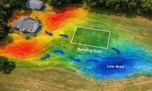
A topographic survey is a detailed mapping of a piece of land that shows elevation contours, natural features, and man-made structures. Conducted by a licensed land surveyor, it measures:
- Changes in elevation
- Trees, rocks, rivers, and wetlands
- Existing buildings, driveways, fences, and utilities
- Drainage patterns and slopes
Unlike a boundary survey, which defines the legal limits of a property, a topographic survey focuses on the physical and spatial characteristics of the terrain—the kind of information engineers, architects, and planning boards rely on.
How a Topographic Survey Differs from a Boundary Survey
| Aspect | Topographic Survey | Boundary Survey |
| Purpose | Maps terrain and elevation | Identifies legal property lines |
| Used For | Site planning, grading, drainage | Ownership disputes, fences, permits |
| Includes | Contours, trees, structures | Bearings, corners, legal boundaries |
| Format | Elevation maps, 3D terrain models | Plats or boundary line diagrams |
A topographic survey doesn’t replace a boundary survey—it complements it. Both are often needed before construction begins.
The Role of a Topographic Survey in Site Planning
Site planners and architects use topographic surveys to:
- Determine suitable building locations
- Design proper grading and drainage
- Assess the feasibility of structures based on slope and elevation
- Identify natural or regulatory obstacles like wetlands or protected trees
Without this data, plans may not meet zoning or environmental standards, leading to delays or costly redesigns.
Why Maine Developers and Engineers Rely on These Surveys
Maine’s variable landscape demands a deeper understanding of the ground you’re building on. A topographic survey helps developers:
- Navigate coastal elevation regulations
- Manage runoff in areas prone to heavy rainfall
- Account for tree conservation laws
- Respond to wetland preservation requirements
From Portland to Bangor, planning boards often require a topographic survey as part of the permit submission packet.
What’s Included in a Topographic Survey Report?
Here’s what you’ll typically find:
- Elevation contours marked in intervals
- Natural features like boulders, tree lines, ditches, and waterways
- Man-made elements such as buildings, walls, and driveways
- Drainage patterns and watershed paths
- Utility locations including power poles, water lines, and sewer pipes
This data is often delivered in CAD files, 3D maps, or hard copy plats for engineers and municipal use.
When It is Required?
You may need a topographic survey when:
- Applying for building permits
- Submitting to local planning boards
- Conducting environmental reviews
- Subdividing land for residential or commercial development
It’s especially important when dealing with sloped or undeveloped land where grading and drainage must be carefully planned.
Who Needs a Topographic Survey?
A wide range of clients benefit from these surveys:
- Homeowners planning additions or landscaping
- Architects and engineers designing buildings and infrastructure
- Contractors needing accurate grading data
- Developers preparing permit applications
- Municipalities reviewing zoning and land use changes
Cost of a Topographic Survey in Maine
On average, a topographic survey in Maine costs between $600 and $2,000, depending on:
- Property size and location
- Terrain complexity and vegetation
- Survey detail level required
- Availability of previous records
For a full pricing breakdown, refer to our property survey cost and pricing guide.
Choosing a Licensed Land Surveyor in Maine
Make sure your surveyor is:
- Licensed by the Maine Board of Licensure for Professional Land Surveyors
- Experienced with site planning and environmental compliance
- Able to deliver CAD, GIS, and paper reports as needed
- Insured and willing to provide references
Choosing a licensed land surveyor in Maine ensures your project is legally and professionally supported.
How Long Does It Take to Complete
Most topographic surveys take 5 to 10 business days, depending on:
- The complexity of the site
- Weather conditions
- Municipal documentation needs
- Scheduling availability
Rush jobs may be possible for an extra fee.
Benefits of Getting a Topographic Survey Early
Ordering a survey early in your planning process offers these advantages:
- Speeds up zoning and permitting
- Improves architectural design accuracy
- Reduces costly grading changes later
- Informs stormwater and utility planning
- Prevents legal delays or rejections
It’s one of the smartest ways to protect your construction investment.
Don’t Break Ground Without a Topographic Survey
From rugged slopes to marshy lowlands, Maine’s terrain demands careful planning—and it all starts with a topographic survey. This vital document gives architects, engineers, and permitting authorities the data they need to approve, design, and build responsibly.
If you’re planning a project in Maine, make sure a topographic survey is at the top of your checklist. It’s not just a requirement—it’s a smart investment in the future of your property.
FAQs
Q1: Can I build without a topographic survey?
Sometimes, but most planning boards and architects require one to ensure safe and legal construction.
Q2: How accurate is a topographic survey?
Very accurate—usually within a few tenths of a foot, depending on equipment and site access.
Q3: What is the difference between a topo and contour map?
A topographic map includes more detail, while a contour map only shows elevation changes.
Q4: Is a topographic survey required for a septic design in Maine?
Yes. It helps determine proper leach field placement and drainage direction.
Q5: Can my old topo survey be reused?
Possibly, if no changes to the land have occurred—but most agencies prefer updated surveys.
Q6: Will the surveyor mark anything on the property?
Typically no. Unlike boundary surveys, topo surveys are mainly for mapping and design.