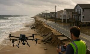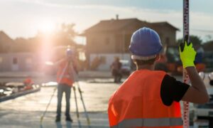
Drone surveying is quickly becoming one of the most useful tools in York. If you’ve seen small drones flying overhead, you might have wondered what they’re up to. Well, they’re not just taking pretty photos they’re helping surveyors, builders, farmers, and even town planners map land faster and more accurately than ever before.
In a place like York, where we’ve got rocky coastlines, rolling farmland, and historic neighborhoods, having the right map can make or break a project.
What Is Drone Surveying, Anyway?
Drone surveying means using drones with special cameras and sensors to map out land. These drones fly over an area and take thousands of detailed pictures. Then, software pieces those images together to create a map or even a 3D model of the land.
That’s a big step up from the old days when surveyors had to walk every inch of a property with heavy equipment. In York, where some areas are tough to reach because of forests, cliffs, or marshes—drones make the job a whole lot easier and quicker.
Why Accurate Land Mapping Matters in York
York is growing, but at the same time, it’s a town that values its history and natural beauty. Between strict coastal rules, old property lines, and environmental protections, there’s not much room for mistakes.
Accurate maps make sure projects don’t get delayed, cost extra, or cause problems with neighbors. For example, if someone is planning to build a new home near Long Sands Beach, a precise survey keeps everything within the rules. If the town wants to restore wetlands or keep track of erosion along the shore, good mapping gives a clear picture of what’s really happening.
Top Benefits of Drone Surveying

1. Super Accurate Results
Drone surveying creates maps and 3D models that are sharp, clear, and very precise. With this technology, you get accurate land mapping with drones that shows property lines, elevation changes, and even small details you’d normally miss on foot. In York, that kind of detail makes a big difference when planning near the coastline or wooded areas.
2. Much Faster Than Old Methods
Instead of spending days out in the field, drones can cover a large area in just a few hours. That means less waiting around for results. For anyone working on construction, farming, or town planning in York, quicker surveys mean projects can move forward without long delays.
3. Saves Money
Because drones work faster and need fewer people on-site, costs drop. Property owners and builders in York can get accurate surveys without paying for weeks of fieldwork. Even small projects benefit from this savings, making professional-level surveying available to more people.
4. Keeps People Safe
Some parts of York aren’t easy or safe to walk through. Think about rocky bluffs, wetlands, or active construction sites. Instead of putting workers at risk, drones fly overhead and capture the data safely. That way, nothing is missed, and no one gets hurt.
5. Works on All Kinds of Land
York is a mix of everything: busy town centers, quiet forests, open farmland, and rugged coastlines. Drone surveying handles all of it. Whether someone needs a survey for farmland outside town, a new neighborhood along Route 1, or erosion studies near the Nubble, drones adapt easily to the job.
6. Better Planning for Everyone
The detailed maps from drone surveying plug right into planning software. That makes it easier for engineers, developers, and even town leaders to see the big picture and make smarter choices.
For example, if the town wants to improve drainage after heavy rains, drone maps can show exactly where the water collects. Or if a farmer wants to plan irrigation, a drone survey can highlight which areas of the field need attention.
Who in York Can Benefit?
The great thing about drone surveying is how many people can use it. Here are just a few examples:
- Builders and Developers – Faster, more accurate site surveys for homes and neighborhoods.
- Farmers – Detailed land maps that help improve crop planning.
- Environmental Groups – Monitoring wetlands, beaches, and forests without disturbing them.
- Town Planners – Making sure growth in York stays balanced and thoughtful.
It’s not just for big companies—small businesses, homeowners, and even the town itself can take advantage of it.
The Future of Drone Surveying in York
Technology keeps moving forward. Drones are flying longer, capturing sharper images, and processing data faster every year. Soon, surveys that once took days might be ready in real time.
For York, that means every project—whether it’s fixing roads, building homes, or protecting the shoreline—can start with reliable and affordable land maps. It’s a tool that helps keep the town’s mix of history, beauty, and progress in balance.
Final Thoughts
Drone surveying isn’t just fancy technology, it’s a practical tool that really fits the way York is growing. From builders breaking ground on new homes to farmers planning their fields and town leaders protecting the coast, it’s helping people all over town with accurate, affordable, and safe land mapping.
And if you’re planning a project yourself, looking into drone surveying services is a smart move. It can save time, cut costs, and give you the confidence that your work is based on reliable data. As York continues to balance growth with its natural beauty, drone surveying will be there to keep projects on solid ground.
