Buying a home near the coast sounds dreamy—until the flood maps start disagreeing. Many buyers are discovering that their listings show “high flood risk” on Flood Factor, even though FEMA maps place their property in a low-risk zone. That mix-up can freeze a loan, raise insurance costs, or even delay closing. If this sounds familiar, you’re not alone. It’s a common problem that’s popping up in real estate forums, and it’s leaving buyers unsure who to trust. The good news? An elevation survey can clear up the confusion and often save your deal.
Why Flood Factor and FEMA Don’t Always Agree
Flood Factor and FEMA may sound like they measure the same thing—but they work very differently.
- FEMA maps are official federal flood insurance rate maps (called FIRMs). They’re used by lenders, insurers, and towns to decide whether a property sits in a special flood zone.
- Flood Factor, on the other hand, is a private tool. It uses computer models, elevation data, and future climate predictions to give every property a “flood risk score.”
That might sound advanced, but the Flood Factor doesn’t always get the complex landscape right. A few feet of slope, a dune, or a seawall can dramatically change risk, yet these local details often don’t show up in national data models.
For buyers, that’s a big deal. You could be looking at a home on higher ground that Flood Factor flags as “severe risk” even though it’s well above FEMA’s base flood elevation. Lenders see that red warning and get nervous. That’s where an elevation survey changes everything.
How an Elevation Survey Works
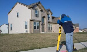
An elevation survey is not just paperwork—it’s fieldwork. A licensed land surveyor visits the property and uses precise instruments to measure the height of your land and foundation in relation to a national standard (NAVD88).
These measurements show your home’s Finished Floor Elevation (FFE) and Lowest Adjacent Grade (LAG)—numbers that prove how high your structure actually sits above flood levels.
Once the survey is complete, the data becomes part of an official FEMA Elevation Certificate. Lenders and insurers rely on this document because it shows real, verified numbers rather than computer guesses.
Think of it as proof that your property is safer than the Flood Factor suggests.
The Problem This Solves for York Buyers
Imagine this: you’re three weeks from closing, your lender suddenly flags the property because Flood Factor lists it as “high risk.” Your insurance quote triples overnight. The seller panics, the agent scrambles, and your dream of living near Long Sands feels like it’s slipping away.
This exact story has been shared on Reddit by frustrated buyers across the country—and it’s starting to appear in Maine too. The delay happens because no one has verified data.
When you provide an elevation survey, everything changes. Your lender has hard proof of your property’s elevation. The insurer can re-rate your policy using accurate ground data. And you, the buyer, can move forward with confidence.
In many cases, the survey shows that the home sits well above FEMA’s Base Flood Elevation (BFE), meaning it’s at lower risk than Flood Factor predicts. That often leads to lower premiums, smoother underwriting, and faster closings.
Why This Is a Bigger Deal Right Now
Flood insurance rules and the National Flood Insurance Program (NFIP) have been in the headlines lately. Every time there’s talk of funding delays or program pauses, lenders become stricter about documentation.
In short, they want facts, not estimates.
With an elevation survey, you provide those facts upfront. It’s the difference between “the model says maybe” and “the survey shows we’re three feet above flood level.” That kind of clarity can save weeks of back-and-forth at the closing table.
The Real Value Beyond Insurance
Sure, saving on premiums matters. But the real power of an elevation survey is peace of mind. When you have official measurements of your property’s elevation, you understand your actual risk—not a guess from a national database.
If you’re planning renovations, that same data helps your builder and the town’s code office approve permits faster. It even protects resale value, since buyers love documentation that proves the home is on safe ground.
For coastal neighborhoods these few feet of elevation make a world of difference.
What Happens During the Process
If you decide to order an elevation survey, here’s what typically happens:
- You contact a licensed surveyor and explain your situation.
- The surveyor visits the site, sets up equipment, and takes precise elevation readings around your foundation.
- They document where the lowest and highest points sit, record mechanical system elevations, and confirm the vertical datum used.
- Within a few days, you receive the results—often including the official FEMA Elevation Certificate.
From there, you can share it with your lender, insurance company, and even your town’s floodplain manager if needed.
Real Stories, Real Savings

Local surveyors have seen buyers cut their annual flood premiums by hundreds of dollars simply by updating their elevation data. One homeowner near Short Sands was marked as “at risk” in Flood Factor but proved to be four feet above the base flood elevation. Their insurer quickly re-rated the policy, saving them nearly $1,000 a year.
Another buyer used the survey to convince the lender to release loan conditions after a Flood Factor scare. The deal closed on time, and the property sold at full price.
In both cases, the solution wasn’t a new insurance plan or a different lender—it was accurate data.
Tips for Buyers Facing Mixed Flood Info
- Don’t panic when you see a high Flood Factor score. Use it as a prompt to get real measurements.
- Ask your lender what documentation they need. Many will accept an updated elevation survey as proof.
- Compare FEMA panels and your survey side by side. Sometimes, a map update or LOMA (Letter of Map Amendment) can make a permanent correction.
- Keep your survey handy. If you sell the home later, that document adds confidence for future buyers too.
Closing Thoughts
In a world full of data, not all data is equal. When it comes to flood risk, only measurements taken on your land can tell the truth. That’s what makes an elevation survey so valuable—it replaces online confusion with certified facts.
If you’re buying in York and see mixed flood results, don’t let that stop your purchase. A simple survey could be the key to unlocking your loan, lowering your premiums, and protecting your investment for years to come.


