How To Find Your Property On FEMA’s Flood Insurance Rate Maps

What are FEMA flood maps?
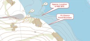
FEMA’s Flood Insurance Rate Maps (FIRMs) or just Flood Maps are provided after a flood risk assessment has been completed or updated for a community.  This study is known as a Flood Insurance Study.  The FIRM gives you the Base Flood Elevations (BFEs) and insurance risk zones in addition to floodplain boundaries.  The FIRM may also show a delineation of the regulatory floodway.

Once the “insurance risk zone”  (commonly referred to as the flood zone) is determined, actuarial rates, based on these risk zones, are then applied for newly constructed, substantially approved, and substantially damaged buildings.  FEMA uses these rates to determine the insurance rate you will pay for flood insurance

FEMA’s Digital Flood Maps

FEMA discontinued the production and distribution of paper flood maps in 2009 as part of its Digital Vision Initiative. This affected all the Flood Maps, boundary information, and study reports. However, clients can still view the products for free through their website or buy them in digital format.

To view these flood maps online, go to FEMA’s Map Service Center and key in your address (hi-lited area shown here) search for your home.  This will prompt you to then select the map that covers your area.  The Flood Maps are somewhat cumbersome to use online. It is best to go through the tutorial on the bottom right of the address search page for an easier and more effective use of the GIS map.

author avatar
Surveyor

More Posts

Surveyors conducting an ALTA title survey on a commercial property site in York
alta survey
Surveyor

How to Expedite Your ALTA Title Survey Without Sacrificing Accuracy 

An ALTA title survey is one of the most important steps in any real estate transaction, especially for commercial properties in York. Buyers, lenders, and developers rely on it to confirm boundaries, easements, and improvements. Yet, anyone who has gone through the process knows these surveys can take time. The

Read More »
Aerial view of a property in York, Maine with visible boundary survey markings, including dashed lines and pinpoints defining the land's perimeter.
boundary surveying
Surveyor

Why a Boundary Survey Matters Before You Build or Buy

Thinking of Buying or Building in York, Maine? Here’s Why You Need a Boundary Survey Whether you’re buying a new home near the rocky coast of York or planning a custom build in a quiet cul-de-sac, there’s one essential step many people overlook: getting a boundary survey. It might not

Read More »
Land surveyor conducting a topographic survey on sloped rural terrain with visible elevation changes and survey tools, ideal for site planning in Maine.
land surveying
Surveyor

Topographic Survey: 7 Reasons It’s Essential for Permits and Site Planning

Maine’s landscape is one of striking variety—from coastal bluffs and wooded hillsides to rural farmland and rocky inland regions. But this natural beauty also comes with challenges for builders and developers. Before you can break ground, you need accurate land data that reflects elevation changes, drainage patterns, and natural features.

Read More »

Why Construction Staking Is the Most Critical Step in Your Building Project

When starting a construction project, most people focus on materials, labor, and permits. But there’s one critical step that often goes unnoticed—construction staking. This process ensures that every structure is built precisely where it should be, following the exact specifications of the plans. Without proper staking, projects can face costly

Read More »

Welcome to ALTA Survey Maine

Your Final Stop for Your ALTA Survey Needs!                              Contact us today for a free quote! This site is intended to provide you with information on ALTA Surveying in Maine. If you’re looking for a Maine Land

Read More »